


The recent floods in Nairobi have left a devastating trail of destruction across the city. Images and videos circulating online show submerged roads, destroyed vehicles, flooded homes, and damaged warehouses. More than twenty people have lost their lives, while hundreds of residents and businesses are counting massive economic losses.
In the aftermath of the disaster, the Johnson Sakaja-led Nairobi City County Government has come under sharp public criticism. Many residents argue that the county administration has failed to fix the city’s drainage systems, leaving Nairobians exposed to the full force of raging floodwaters.
Public anger is not entirely misplaced. There is a widely held belief that although the county government has the resources and institutional capacity to develop effective drainage infrastructure, corruption, poor planning, and administrative inefficiency have undermined flood mitigation efforts. Funds meant for flood control are often alleged to be mismanaged or diverted, resulting in poorly designed or incomplete drainage projects.
While corruption and incompetence certainly weaken flood control measures, it is important to examine the issue more critically. The scale and intensity of the recent flooding were unusually severe compared to previous rainy seasons. This suggests that the problem is not merely about blocked drains or inadequate pipes. To understand why floods occur at such magnitude, we must first understand the natural processes that govern the movement of water.
Understanding the Water Cycle
In hydrological science, there is a fundamental concept known as the Water Cycle, also referred to as the Hydrological Cycle. This cycle describes the continuous movement of water between the Earth’s surface, the atmosphere, and underground systems. Water constantly circulates through different forms; liquid, vapor, and ice and moves through oceans, rivers, soil, and the atmosphere. The basic sequence of the cycle is as follows:
- The sun heats water in oceans, lakes, and rivers.
- Water evaporates into the atmosphere.
- The vapor condenses to form clouds.
- Clouds release precipitation in the form of rain.
- Rainwater infiltrates the ground or flows as surface runoff.
- Water collects in streams, rivers, lakes, and oceans.
This cycle is continuous and self-sustaining. Water is neither created nor destroyed within the system it simply changes form and location. When heavy rainfall occurs, the excess water must move somewhere. Ultimately, almost all surface runoff flows toward a final destination, the ocean. The general pathway of floodwaters follows this sequence;
Rain → Surface Runoff → Streams → Rivers → Estuaries or Deltas → Ocean
However, not all water travels the same way. Some of it infiltrates the soil and becomes groundwater. It moves slowly through porous rock layers known as aquifers, eventually emerging through springs or flowing beneath riverbeds toward the sea.
This underground movement is gradual and rarely causes destructive flooding.
Another portion of water is absorbed by plants through their roots and later released back into the atmosphere through transpiration. Like groundwater movement, this process also typically has minimal destructive impact on the surface.
The most destructive form of water movement during heavy rainfall is surface runoff, the fast-moving water that flows across land before entering streams and rivers.
Topography and the Movement of Floodwater
To understand flooding in Nairobi, we must consider the concept of Topography, which refers to the elevation and slope of land surfaces. Areas with steep slopes tend to experience faster surface runoff because gravity accelerates the movement of water
downhill. Conversely, low-lying areas tend to accumulate water, making them more vulnerable to flooding.
Nairobi, according to the Nairobi Topographic Map sits on a highland plateau with an average elevation of about 1,729 meters above sea level. Within the city and its surrounding regions, there are distinct variations in elevation. Higher areas include areas such as Ngong Hills, Karen, Lavington, Kitisuru and Runda
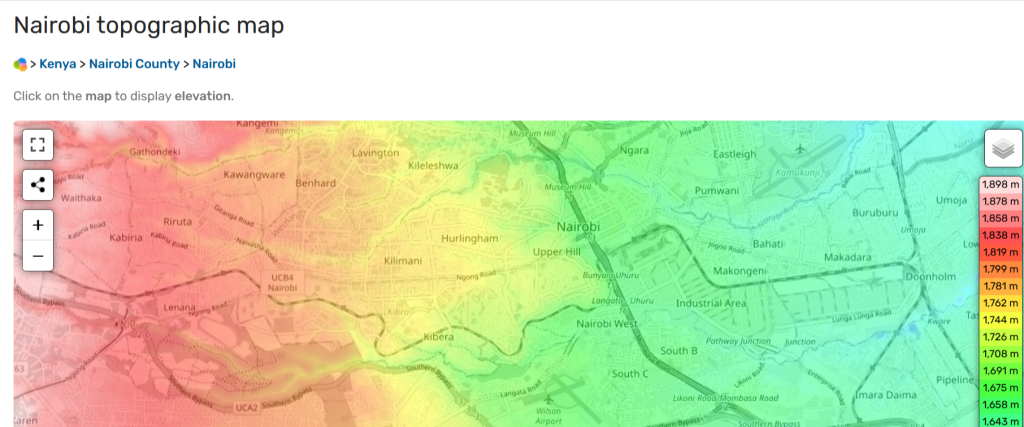
Medium elevation areas include, Central Business District, Westlands, Kilimani and Upper Hill while lower elevation consists of areas such as, Eastlands, Dandora, Embakasi and Ruai.
Because of gravity, rainwater naturally flows from the higher western and northern regions of the city toward the lower eastern and southeastern areas. This means that low-lying neighborhoods often receive not only the rain falling within them, but also runoff water flowing downhill from multiple upstream areas.
When the Entire Region Receives Heavy Rainfall
Flooding intensity is also determined by how much rain falls and how quickly it falls. Sometimes rainfall is uneven. One area receives heavy rain while another remains relatively dry. In such situations, flooding can be limited because runoff flows into areas experiencing less rainfall. However, when an entire region experiences simultaneous heavy rainfall, the situation becomes far more dangerous. Low-lying areas receive water from three sources at once;
- Rain falling directly in the area
- Runoff water from higher elevations
- Overflow from nearby rivers and drainage channels
The result of this is a sudden accumulation of large volumes of fast-moving water. This is similar to countless individual raindrops falling separately from the sky but eventually merging on the ground into a powerful flowing mass.
Why Drainage Pipes Alone Cannot Solve Flooding
This brings us to the central issue. Flood control cannot be reduced to the installation of drainage pipes, culverts, or trenches.
While such infrastructure is important, it addresses only a small part of the hydrological system. Drainage projects are often politically attractive because they are visible and easy to communicate as solutions. Leaders can point to pipes and culverts as evidence that action is being taken. But in reality, effective flood management requires something much large. A comprehensive hydrological infrastructure system.
Water must ultimately travel through the full natural pathway of the hydrological cycle, from rainfall to runoff, to streams, to rivers, to estuaries, and finally to the ocean.
Flood control systems must therefore be designed in alignment with this entire pathway. If flood mitigation measures are implemented in only one geographic area without considering upstream and downstream regions, the result is simply the transfer of flooding
from one location to another.
Nairobi Within a Larger Hydrological System
Nairobi is not an isolated hydrological system. It sits within several interconnected watersheds. Runoff water from upstream regions converges into three major river systems; Nairobi River, Ngong River and Mathare River. These rivers carry water eastward beyond Nairobi
toward the semi-arid counties of Machakos and Kitui. Eventually, these water systems connect with tributaries of the Tana River, Kenya’s largest river system.The Tana River then flows eastward and finally empties into the Indian Ocean near Malindi and Kilifi.
This means floodwater passing through Nairobi is only part of a much larger regional water system. Flood Control Must Be Regional, Not Local.
Effective flood management must therefore be planned across entire hydrological corridors,from upland regions to coastal outlets.Such infrastructure could include;
- watershed management systems
- upstream retention basins
- wetlands restoration
- flood plains
- Nairobi, Ngong and Mathare river channels expansion
- urban green infrastructure
- large-scale drainage networks connected to river systems.
These measures must be coordinated across multiple counties and government agencies, because water does not respect administrative boundaries. Building such infrastructure is expensive and complex. It requires long-term national planning, scientific expertise, and regional cooperation. However, without such systemic thinking, cities like Nairobi will remain vulnerable.
Pipes Are a Short-Term Measure
Drainage pipes and culverts should therefore be understood as temporary mitigation measures, not permanent solutions. They can reduce localized flooding in urban neighborhoods, but they cannot control the full hydrological forces that drive large-scale flooding. Real solutions require a national commitment to developing hydrological infrastructure across the country, beginning with major cities such as Nairobi, Mombasa, Kisumu and Nakuru. From there, such systems can gradually expand to other urban centers. This transformation
will take years, perhaps decades. But the process must begin now.
If the recent floods in Nairobi fail to trigger serious reflection and long-term planning, the country may soon face disasters far worse than the one it has just experienced.


